Without any preamble let's get straight to the business in hand.........yesterday I finished after having just visited Chulilla. But now it was time to see what damage had been done elsewhere.
Again there was no real possibility of getting up close and personal the fires, so I opted for the next best thing and left the CV35 to take a mud track which ran more or less parallel to the highway so that we were driving through a thin band of woodland that lies sandwiched between the highway and the fires.
As we drove down the track it soon became very obvious that the extent of the destruction was far more apparent and widespread than it had been around Chulilla. Fires were visible at almost every turn of the track - to try and estimate the number of blazes would be impossible and again we stopped to watch the disaster unfolding before our eyes (Figures 1-3).
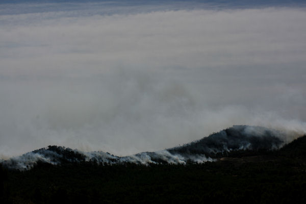
Figure 1. The tops of almost every hill and ridge were swathed in smoke. This was just one of many sadly.
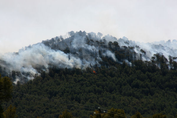
Figure 2. The wind was still blowing a gale and occasionally we saw the fires flare bright orange as the wind whipped it into a fury.

Figure 3. This fire was burning its' way back down the slopes of the ridge against the wind.
The whole thing was depressing and sad. After a time I couldn't stand it any longer and went home.
I don't know exactly how many fires we had had locally during this summer but however many it was, it was way too many. The TV said this fire had destroyed about 7,000 hectares in the end. The big fire at Andilla earlier this summer 70,000 hectares. But it seemed that almost every day a new fire was being reported on the local news, many of them small, manageable and perhaps charring only a few hundred hectares - hardly worth mentioning in the scale of things - but some days there were 5, 6 or more of these happening.
When I stand on my terrace and decide which route I am going to cycle that particular day, I think about the wind direction, the temperature and also the beauty that I may get to take in. Now, it doesn't matter which way I go, if I want to cycle mountain routes locally, then every single direction has been burned to a crisp this summer. There isn't a single route that isn't charred, stinking and ravaged.
Climate change has Spain towards a much drier, hotter future. Some say that within 50 years large parts of Spain will be reclassified as desert regions. As Murphy's Law would have it, 2 days after making the rounds and taking the photos above, the drought which had lingered on for just a few days short of 18 months, broke and the past weekend we were treated to rainfall on a massive scale - which in itself caused flooding, deaths and more mayhem. But that, as they say, is another story.
The rain has finally put paid to the threat of fires until next year, when it may all start again. I realise how lucky we have been this year in truth. Our tiny valley was the only region left untouched by fire this summer and despite their close proximity the fires did not affect us directly. But will we be as lucky again next summer?
The rain continued to fall in torrents for 3 days and finally doused the last remaining fires around Chulilla and Pedralba. But the cost had been high, for the environment, the Spanish pocket and the people who have been affected by the fires. When the rain abated yesterday I went off to see the damage.

Figure 4. 1.- Chulilla.
2.- The factory where the fire is thought to have started.
The big flat-topped mountain is now bald. There is nothing left.

Figure 5. Normally lush and verdant in the valley with the mountains swathed in shrubs and small pines. Now again...... all gone.

Figure 6. The river valley below Chulilla was a favourite place for tourists. There were countless places beside the river for picnic and/or swimming. It was always shady, verdant and pleasant with banks overcrowded with bamboo growing to the height of a house. But today, all the bamboo is gone, the river banks are thick with ash and the water is polluted.

Figure 7. The factory where the fire may have started. Amazingly it looks untouched!

Figure 8. The factory is set in the side of the valley with Chulilla behind it and the flat-topped mountain in front. All the trees you see here are dead.
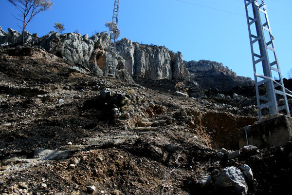
Figure 9. The flat-topped mountain in close up....you can see all there is left are blackened rocks and charred soil.

Figure 10. Chulilla before the fires.....I hope you can see clearly how the mountains are covered in vegetation.
1.- Chulilla.
2.- The factory.

Figure 11. The mountain now devoid of life.

Figure 12. Black, black and more black.

Figure 13. Not a hugely spectacular photo but one that illustrates the new status quo around Chulilla.

Figure 14. This is an area of national park, a place of beauty and serenity and a fine place for a walk. But now that is ended. In every direction the story was the same - destruction! The area seen here is normally a small parkland place with benches, tables and BBQ areas - but no more!
Tomorrow I shall go over to Pedralba, Bugarra and Gestalgar to survey the damage. I'll be back with that news very soon.
Ciao!
looks terrible, all those lovely places GONE!
ReplyDeleteDylan xxx
It really is terrible mate.....thanks for your comment.
DeleteDadXXX
Hi there. One year on, how's it looking now. Have the hillsides come back to life???
ReplyDelete